Heritage Context
Understanding the historic character of Newbury and the site's place within the Conservation Area
Existing Character of Newbury
The majority of Newbury town centre is within the Conservation Area and contains a concentration of designated and non-designated heritage assets. The buildings within the town centre vary in age, quality, and architectural styles, creating a varied and interesting townscape. These buildings span multiple periods from the medieval era to the modern age.
The dense historic medieval core of Newbury is centred around Northbrook Street to the North of the town centre, and Bartholomew Street and Cheap Street to the West and East, converging at the bridge over the River Kennet. The street pattern of Newbury retains its fundamental medieval route structure, reflecting its historical role as a centre of mercantile trade. Wide streets and open spaces, historically used for markets, continue to serve as primary shopping routes, with a tighter urban grain surrounding, including numerous passages and alleys, such as The Arcade, The Eight Bells, and Weavers Walk, which link these spaces and contribute to the town’s character. The older buildings generally rise between two and four storeys, with taller landmarks such as the clock-tower of the Victorian town hall.
Modern and contemporary developments, such as the mixed-use Parkway development and Weavers Yard, take cues from the range of architectural styles found in the town centre but are generally contemporary in character, consist of large blocks and are taller than the prevailing town centre, between 3 and 9 storeys in height.
Site Prior to the Kennet Centre
The triangular area between Bartholomew Street, Cheap Street and Market Street that comprises the Kennet Shopping Centre was one of the earliest occupied areas of the medieval town. Evidence from archaeological excavations by Oxford Archaeology have shown it was laid out with burgage plots (enclosed fields used for agriculture or small-scale farming) along both sides until the 18th century.
Between the late eighteenth and nineteenth centuries, the built form was predominantly composed of small-grained blocks, characterised by central buildings which were surrounded by smaller ancillary structures or outbuildings. Hardstanding areas were evident between buildings forming yard areas and spaces for storage.
The Northern areas of the site were notably denser. In terms of scale, the buildings varied between one and three storeys. Brick is evident as the prominent material used in buildings and structure, with a mix of gabled and hipped roofs above, echoing the wider traditional architectural forms within the town centre. Tall brick chimneys were a prominent feature in the roofscape, not only serving functional purposes but also contributing to the visual identity of the area.
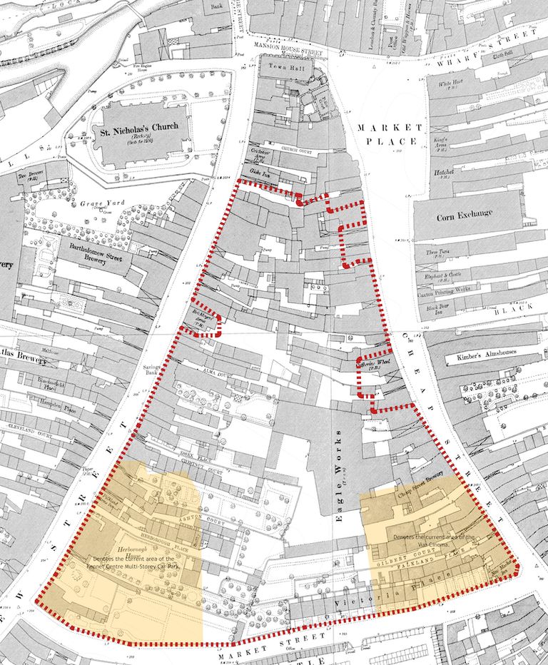
1880’s Historic Map
The historic map shows the application site and surrounding context as it once was before the demolition and the construction of the Kennet Centre, the Cinema and the Kennet Centre Multi-storey Car Park.
We can see from this map the east-west axis of the linear burgage plots that present a tight-knit environment of Yards, Courts and Places behind a large building that addresses the main movement routes. We can observe from this map the gradual loss of ‘white space’ within the site. This is as a consequence of backfill development being undertaken within the burgage plots, gradually increasing the density and mass over time.
The Yards, Courts and Places contained modest living accommodation, and cottage industries, along with the larger industrial units, such as Eagle (Iron) Works.
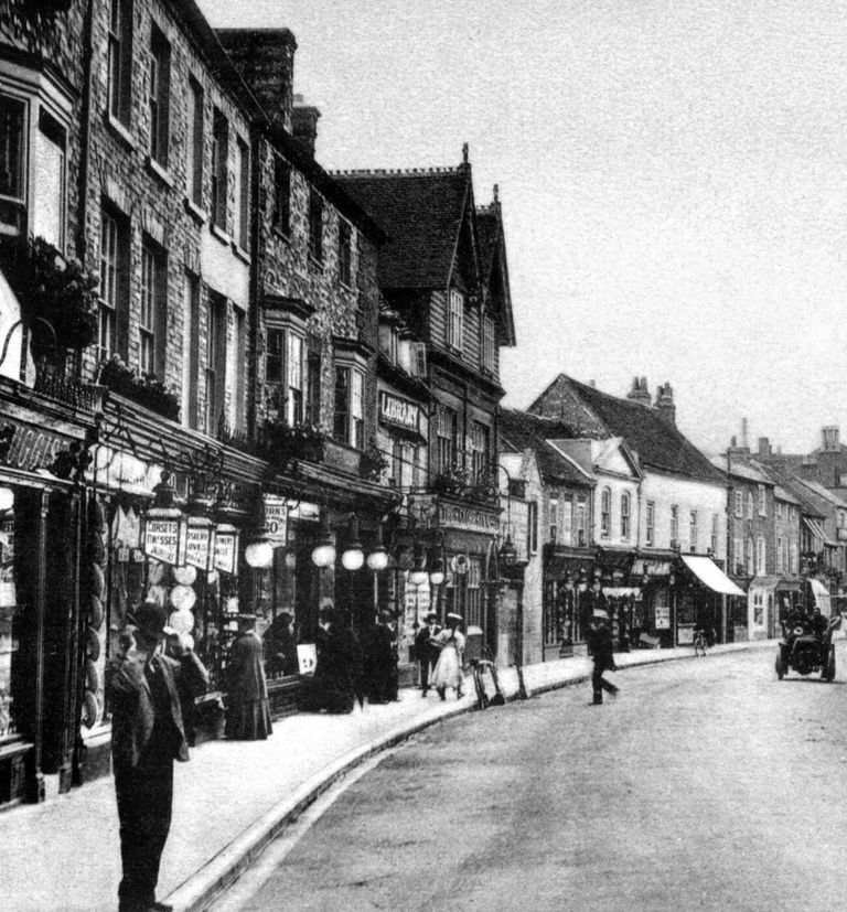
Early 1900’s Bartholomew Street
We can see from this photograph the sweeping building frontage following the street. The Globe Inn (the double-gabled fronted building) is a landmark in the photo that still exists. However, when we compare this photo with the street scene today, the mix of building forms, scales and materials that underpin the character of the Conservation Area has been lost, mainly due to the construction of the Kennet Centre.
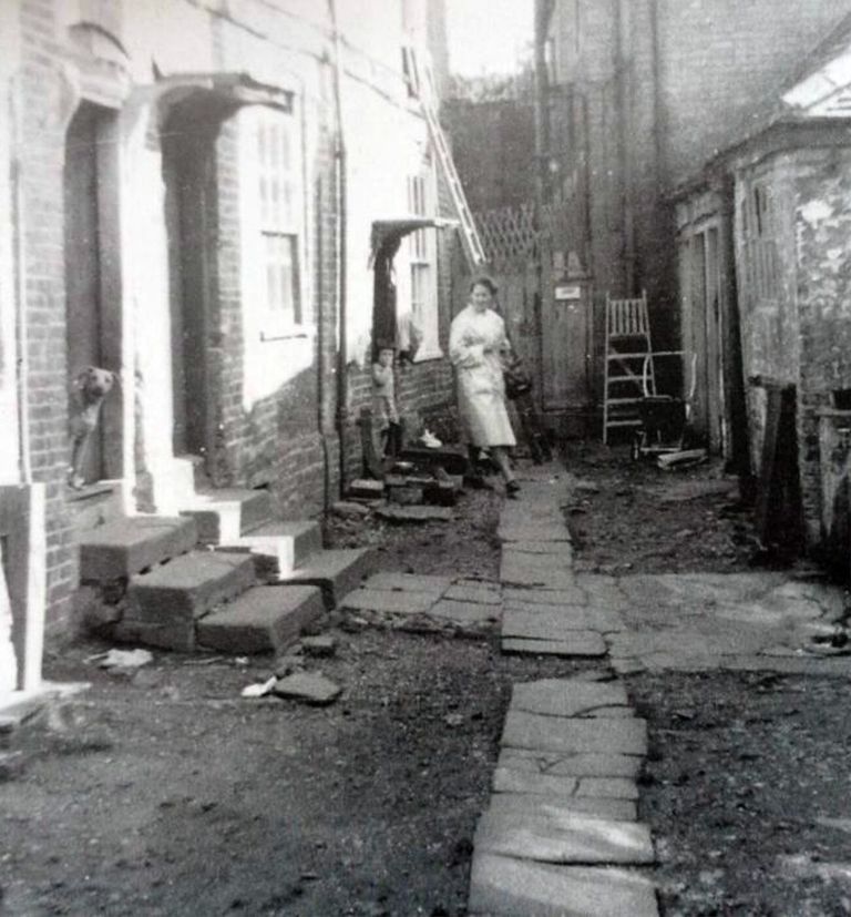
1940’s Living Quarters – Crown Court
A rare glimpse of life within the burgage plots, this photograph illustrates the tight-knit built environment within Crown Court – previously off Bartholomew Street between The Bricklayers Arms (now The Newbury) and The Globe Inn.
We can observe the modest Georgian houses with their sliding sash windows, brick arches, string courses, modest porches and stepped thresholds opposite a wash/pump house. Crown Court can be seen on the 1880’s Map, which confirms the close built environment these dwellings often existed within, as is the case here, with little or no amenity space, save for the frontage passageway.
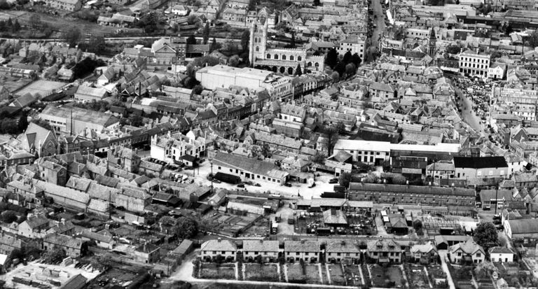
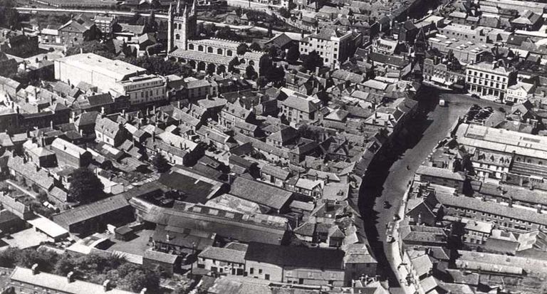
c.1940’s Aerial Photo
Illustrates the tight-knit character, varying building scale, typology and juxtaposition of roof forms. The c.1940’s and 1950’s photographs show the densely knitted development of the site prior to the development of the Kennet Centre. These photographs are comparable to the built-form layout illustrated in the c.1880’s Map.
The photographs clearly illustrate the following Newbury Town Conservation Area characteristics; tight-knit built-form environment; an East-West axis of deep plots served by Carriage Arches, Ginnels and Passageways; a transition of high mass to lower mass from North to South; a wonderful juxtaposition of roof forms, differing building typologies, differing scales and orientations; use of Courts and Yards as amenity space with limited or no vehicular access, i.e. virtually all the dwellings had predominantly pedestrian access.
c.1950’s Aerial Photo
Little had changed over 10 years, save for building forms and materials around the Eagle Works area.
Figure-Ground Plan Comparison
Comparing the historic, present and proposed figure-ground plans reveals how the site’s character has been lost and how it can be restored.
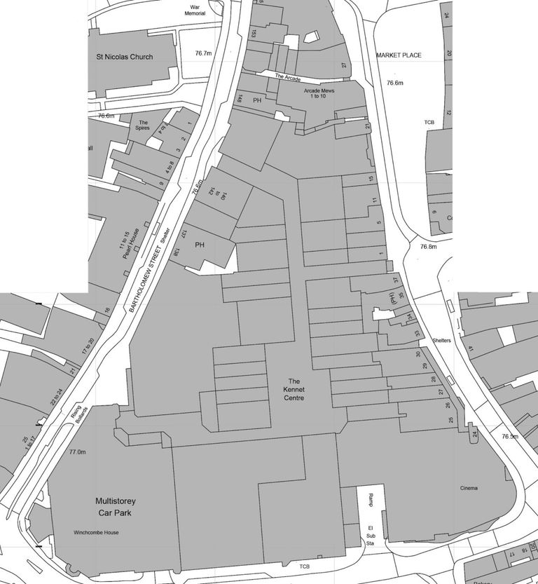
Present Figure-Ground Plan
The shopping centre layout removes all historic characteristics from the site, alien to the character of the wider Conservation Area. Not only this, the Kennet Centre presents a monolithic mass of built form that is impenetrable, aside from the access through the site during daytime hours.
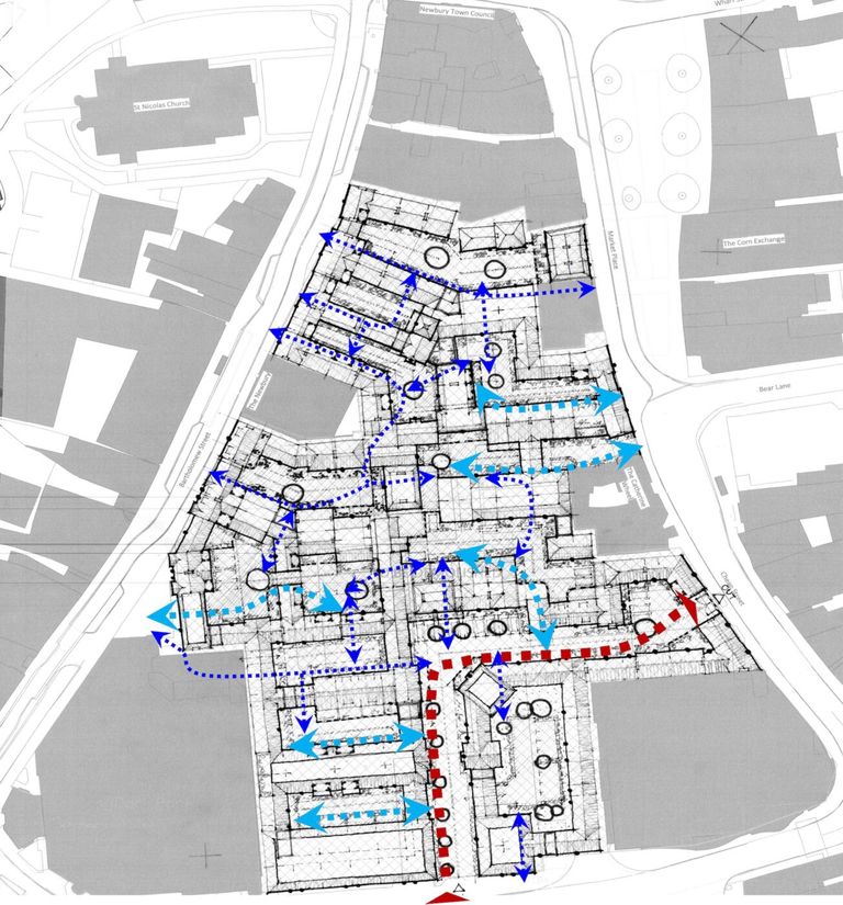
Early Concept Layout
The design team explored numerous layout solutions that sought to reintroduce the historic urban grain character that reflected the 1880’s Map but also delivered a development that catered for modern expectations. The Concept Layout shows how linkages through Carriage Arches, Ginnels and Passageways into Yards, Courts and Places can be created when the site connects to the surrounding streets.